
Afan Forest Park – Visitor Centre, near Port Talbot
Main starting point for mountain bike and walking...

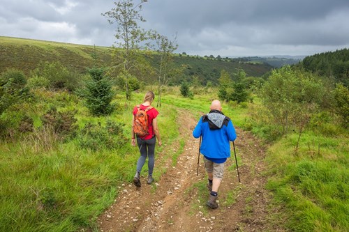
The Tower entrance has a small parking area which is the starting point for a walking trail with valley views within Brechfa Forest.
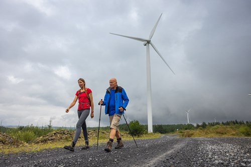
For a closer view of the wind turbines you can connect to a much longer walking trail from here - see the information about the Wind and Water Trail below.
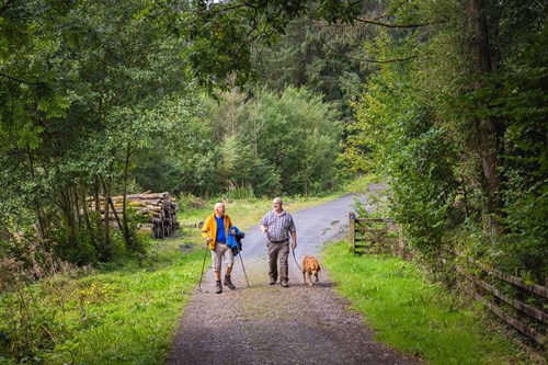
The walking trails are waymarked from start to finish.
Look out for the information panel at the start of the trail.
Find out about walking trail grades.
Enjoy views of the Marlais Valley on the return leg of this walking trail.
This walking trail was created in partnership with RWE who developed the Brechfa Forest West Wind Farm within this part of the forest.
Get close to the huge turbines of Brechfa Forest West Wind Farm on our Wind and Water Trail.
This circular 12 mile/19.3 kilometre walking route sets off from Keepers car park.
You can also connect to the Wind and Water Trail from Tower car park by following part of the Marlais Valley Walk and a link route but please note that the overall walk will be much longer.
For more details, see the information panel in both car parks.
This walking trail was created in partnership with RWE who developed the Brechfa Forest West Wind Farm within this part of the forest.
Brechfa Forest is the modern name for part of the ancient Glyn Cothi Forest.
Glyn Cothi Forest was managed for centuries by local people in order to provide building materials, products and grazing.
In 1283, following the final defeat of Wales by Edward I, Glyn Cothi became a Royal Forest administered under Forest Law for several centuries.
Since those days a very different forest has developed. In the 1900s Brechfa Forest was replanted with conifers by the Forestry Commission to boost Britain’s timber reserve after the heavy use of timber in the First World War.
Brechfa Forest covers some 6500 hectares and is looked after by Natural Resources Wales for the benefit of people, wildlife and timber production, and more recently the production of wind energy.
There are walking and mountain bike trails from these other Natural Resources Wales car parks in Brechfa Forest:
Brechfa Forest forms part of the National Forest for Wales.
The National Forest will:
It will form a connected ecological network running throughout Wales, bringing social, economic and environmental benefits.
Parts of the network will eventually form a trail running the length and breadth of Wales, so anyone can access it wherever they live.
For more information go to the National Forest for Wales website.
We want you to return home safely after your visit here.
You are responsible for your own safety as well as the safety of any children and animals with you during your visit.
For advice and tips to help you plan your visit here go to Visiting our places safely.
See the top of this webpage for details of any planned closures or other changes to visitor facilities here.
For your safety, always follow instructions from staff and signs including those for trail diversions or closures.
We may divert or close trails whilst we undertake maintenance work or other operations and we may need to close other visitor facilities temporarily.
In extreme weather, we may close facilities at short notice due to the risk of injury to visitors and staff.
You may need permission from us to organise an event or to carry out some activities on our land.
Check if you are allowed to use our land.
The Tower car park is 14½ miles north east of Carmarthen.
The postcode is SA39 9EJ.
Please note that this postcode may not take you to the car park if you use a sat nav or navigation app.
We suggest you follow the directions below or use the Google map on this page which has a pin on the car park’s location.
Take the A484 from Carmarthen towards Llandeilo and Carmarthen hospital.
At the roundabout just after the hospital take the A485 towards Lampeter.
Follow the A485 for around 10 miles until entering the village of New Inn.
At the cross roads in the village turn right onto the minor road signposted for Brechfa.
After 1¾ miles the parking area is on the right.
View this place on the What3Words website.
The Ordnance Survey (OS) grid reference for the car park is SN 495 354 (Explorer Map 186).
The nearest mainline railway station is in Carmarthen.
For details of public transport go to the Traveline Cymru website.
Parking is free of charge.
Overnight parking is not permitted.
There are no staff at this location.
Contact our customer team for general enquiries during office hours, Monday to Friday.


