
The Arch, near Aberystwyth
Walks through huge beech trees with views over...

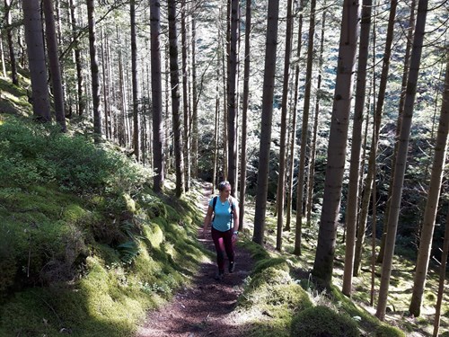
Coed Maen Arthur is a woodland in the Ystwyth valley near the village of Pont-rhyd-y-groes.
The waymarked walk goes through the woodland to Castell Grogwynion, one of the largest hill forts in Wales, and passes near an impressive waterfall.
This area was once home to a busy lead-mining industry - look out for the information panel next to the water wheel in the village.
The walk is reached via a wooden bridge high over a deep river gorge - this bridge replaced the one used by mineworkers which is thought to have collapsed.
Coed Maen Arthur is especially beautiful in autumn when the trees are ablaze with seasonal colours of yellow and red.
The walking trail is waymarked from start to finish.
Look out for the information panel at the start of the trail.
Find out about walking trail grades.
The Maen Arthur Trail climbs the wooded hillside of the Iron Age hill fort and emerges into a clearing with views over the trees and down into the valley.
The route goes past a spectacular waterfall and then follows the fast-flowing river.
It returns via a path along the bottom of the gorge.
Coed Maen Arthur forms part of the National Forest for Wales.
The National Forest will:
It will form a connected ecological network running throughout Wales, bringing social, economic and environmental benefits.
Parts of the network will eventually form a trail running the length and breadth of Wales, so anyone can access it wherever they live.
For more information go to the National Forest for Wales website.
We want you to return home safely after your visit here.
You are responsible for your own safety as well as the safety of any children and animals with you during your visit.
For advice and tips to help you plan your visit here go to Visiting our places safely.
See the top of this webpage for details of any planned closures or other changes to visitor facilities here.
For your safety, always follow instructions from staff and signs including those for trail diversions or closures.
We may divert or close trails whilst we undertake maintenance work or other operations and we may need to close other visitor facilities temporarily.
In extreme weather, we may close facilities at short notice due to the risk of injury to visitors and staff.
You may need permission from us to organise an event or to carry out some activities on our land.
Check if you are allowed to use our land.
Coed Maen Arthur is 14 miles south east of Aberystwyth.
The postcode is SY25 6DQ.
Please note that this postcode may not take you to the start of the trail if you use a sat nav or navigation app.
We suggest you follow the directions below or use the Google map on this page which has a pin on the water wheel's location.
Take the B4340 from Aberystwyth to Trawsgoed.
Follow this road through Trawsgoed and turn immediately left after crossing the stone bridge.
Follow this road past the entrance for Ty’n y Bedw Wood and for a further 3 miles to the village of Pont-rhyd-y-groes where the Lisburne mine water wheel will be on the right.
To reach the start of the trail go through the footpath gate opposite the water wheel and across the bridge over the gorge - look out for the information panel on the other side of the bridge.
View this place on the What3Words website.
The Ordnance Survey (OS) grid reference for the start of the trail is is SN 738 722 (Explorer Map 213).
The nearest mainline railway station is in Aberystwyth.
There is a bus service from Aberystwyth to Pont-rhyd-y-groes.
For details of public transport go to the Traveline Cymru website.
The trail starts near the Lisburne mine water wheel in the village of Pont-rhyd-y-groes.
To reach the start of the trail you need to go through the footpath gate opposite the water wheel.
There is not a car park at the start of the trail so please park considerately in the village.
There are no staff at this location.
Contact our customer team for general enquiries during office hours, Monday to Friday.


