
Beddgelert Forest, near Beddgelert
Huge forest in the heart of Eryri (Snowdonia)...

Cadair Idris National Nature Reserve is made up of a range of mountains in the south of Eryri (Snowdonia) National Park.
There are accessible paths around Dôl Idris parkland and two short but steep waymarked trails into the reserve.
The Minffordd Path to the summit of Cadair Idris also sets off from here.
The main access to Dôl Idris parkland and Cadair Idris National Nature Reserve is from the Eryri (Snowdonia) National Park Authority's car park just off the A487.
These four walking trails are waymarked from start to finish.
If you prefer a gentle stroll on flatter ground or a peaceful picnic by the lake try Eryri (Snowdonia) National Park Authority's accessible Dôl Idris Lake Walk or easy Parkland Circuit.
There are also two Natural Resources Wales trails which take you part way up the steep climb onto the National Nature Reserve and mountain: the short Gorge Climb with views of the waterfalls, and the longer climb to the Nant Cadair Bridge.
Look out for the information panel at the start of the trails.
Find out about walking trail grades.
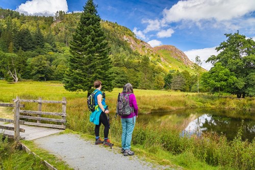
This circular route starts from the car park and goes all the way around the lake in the parkland.
Look out for birds such as the dipper and grey wagtail, which breed on the lakeshore, and the fish ladder near the footbridge that helps salmon to reach the streams.
This circular route passes through the parkland with its exotic specimen trees.
Look out for the ruined building where Idris table water and ginger beer were first made and the bat boxes.
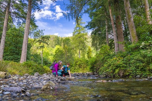
Follow the maroon symbols up the steep gorge to a bench with views across to the waterfall.
The route goes through the ‘Celtic Rainforest’ with its range of internationally important species of moss.
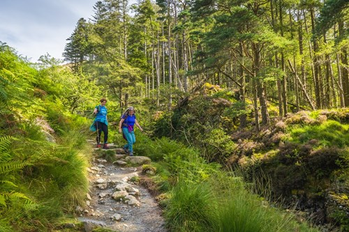
Follow the orange symbols on a long steep climb up the gorge.
The trail goes past the waterfalls, where there’s a bench to catch your breath.
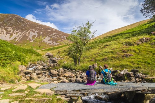
It then continues onto the lower slopes of the open mountain to the Nant Cadair slate bridge.
This very strenuous climb is not waymarked.
You need a map, navigational skills and a good level of fitness.
Wear good walking shoes.
The temperature at the top can be several degrees lower than in the car park and low cloud often covers the summit so it can be damp as well as cold - take suitable clothing with you.
For more information about the Minffordd Path go to the Eryri (Snowdonia) National Park Authority website.
Cadair Idris is a National Nature Reserve.
National Nature Reserves are places with some of the very finest examples of wildlife habitats and geological features.
The landscape and wildlife varies depending on which time of year you visit – here’s what to look out for.
If you’re lucky, you may spot peregrine falcons hunting above the high crags, or a shy ring ouzel in the steep rocky ravines.
Wheatears return to the mountain too, whilst chiffchaffs and willow warblers can be heard singing all around the visitor centre at the foot of the reserve.
Many woodland plants such as primrose and wood anemone come into flower, and the oaks show signs of bursting into life again.
Summer sees the welcome return of the classic trio of Welsh oakwood birds: pied flycatcher, wood warbler, and redstart, as well as the swallows and housemartins that often nest under the visitor centre eaves (visitor centre currently closed).
On the cliffs in early summer, arctic-alpine plants are at their best, some of which are seen nowhere further south in Wales.
In flower at the same time is the locally rare hairy greenweed that grows here at it's northernmost location!
Later the dry slopes are clothed in a carpet of purple heather, punctuated here and there by the yellow flowers of western gorse.
The bogs glisten with the sticky sundews, accompanied by bog ashopodel and heath spotted orchids, whilst dragonflies patrol their patches.
The rare lesser horseshoe bats return to their breeding roost in the roof of the visitor centre and, in the exhibition, you can watch live infrared footage of the females nursing their young in July.
The dense canopy of the Celtic rainforest takes on its rich seasonal tapestry of colours, and a wealth of fungi produce their fruiting bodies on the woodland floor.
The increased rain swells Nant Cadair stream, raising the humidity in the gorge under the shade of the trees, making conditions ideal for a variety of very rare mosses and liverworts.
With fewer visitors on the mountain it is a good time to explore the reserve. Look for the dainty flowers of ivy-leaved bellflowers and wild thyme.
Choughs occasionally visit the grassy slopes to forage for insects and grubs with their stunning red curved beaks.
The hardier butterflies such as peacocks still emerge to feed on fine days, along with the odd bilberry bumblebee, an uncommon upland species with its seemingly bright red rump!
Winter is a good time to appreciate the stunning geology of Cadair Idris.
The valley of Cwm Cau is a classic result of the last ice age, with sheer cliffs, a thousand feet tall at one point, almost encircling Llyn Cau, one of Wales' deepest natural lakes. It is said to be bottomless, with a monster lurking within! You may not ever see this mysterious creature, but if you are very lucky, you could possibly see a stoat in its white winter coat, hunting its prey amongst the screes.
Elsewhere on the reserve, you can see other clues to the sites' geological past such as pillow lavas and smooth rock faces, scoured by the slow moving iceflow.
There are over 70 National Nature Reserves in Wales.
Find out more about National Nature Reserves
Local folklore describes Idris as a giant who lived on this magnificent mountain; Cadair Idris is Welsh for “Idris's chair”.
The large boulders on the lower slopes are supposed to be the debris from stone throwing battles between Idris and the other giants.
It is said that if you are lucky enough to survive a night on the summit, the ordeal will either drive you mad or turn you into a poet.
This film is bi-lingual. The Welsh version plays first and the English version follows after seven minutes.
Cadair Idris is in Eryri (Snowdonia) National Park.
Eryri is the largest National Park in Wales and is home to picturesque towns and villages and the highest mountain in Wales.
It is looked after by the Eryri National Park Authority.
For more information about visiting Eryri (Snowdonia) go to the Eryri National Park Authority website.
We want you to return home safely after your visit here.
You are responsible for your own safety as well as the safety of any children and animals with you during your visit.
For advice and tips to help you plan your visit here go to Visiting our places safely.
Facilities include:
The car park is managed by the Eryri National Park Authority. For information about opening times and parking charges go to the Eryri National Park Authority website.
The toilets in the car park are managed by the Eryri National Park Authority and are open daily (not 24 hours).
See the top of this webpage for details of any planned closures or other changes to visitor facilities here.
For your safety, always follow instructions from staff and signs including those for trail diversions or closures.
We may divert or close trails whilst we undertake maintenance work or other operations and we may need to close other visitor facilities temporarily.
In extreme weather, we may close facilities at short notice due to the risk of injury to visitors and staff.
You may need permission from us to organise an event or to carry out some activities on our land.
Check if you are allowed to use our land.
Cadair Idris National Nature Reserve is 10 miles south of Dolgellau.
The postcode is LL36 9AJ.
Please note that this postcode may not take you to the car park if you use a sat nav or navigation app.
We suggest you follow the directions below or use the Google map on this page which has a pin on the car park’s location.
The main access to Cadair Idris National Nature Reserve is via the Dôl Idris car park.
Take the A487 from Dolgellau towards Machynlleth and turn right onto the B4405.
The entrance to the Dôl Idris car park is immediately on the right.
View this place on the What3Words website.
The Ordnance Survey (OS) grid reference for the car park is SH 732 115 (Explorer Map OL 23).
The nearest mainline railway station is in Tywyn.
Local bus services run from Tywyn.
The Traws Cymru bus service runs along the A487 between Aberystwyth and Bangor and stop at the junction with the B4405 near the car park.
For details of public transport go to the Traveline Cymru website.
The main access to Cadair Idris National Nature Reserve is via the Dôl Idris car park.
This car park is on the B4405, just off the A487 between Dolgellau and Machynlleth.
The car park is managed by the Eryri National Park Authority.
There is a parking charge.
For information about opening times and parking charges go to the Eryri National Park Authority website.
There are no staff at this location.
Contact our customer team for general enquiries during office hours, Monday to Friday.


