
Beddgelert Forest, near Beddgelert
Huge forest in the heart of Eryri (Snowdonia)...

Foel Friog is set within the spectacular landscape of Dyfi Forest.
It is near the village of Aberllefenni and is easy to find from the A487.
Discover ancient oaks, a derelict farmstead and superb views on the circular walking trail to the top of Pen y Bryn hill.
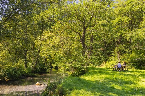
There are several picnic tables in a large riverside grassy area near the car park.
The walking trail is waymarked from start to finish.
Look out for the information panel at the start of the trail.
Find out about walking trail grades.
Follow the red waymarkers to cross Afon Dulas river and then climb up the hill on a steep path through oak woods to the Pen y Bryn derelict farmstead.
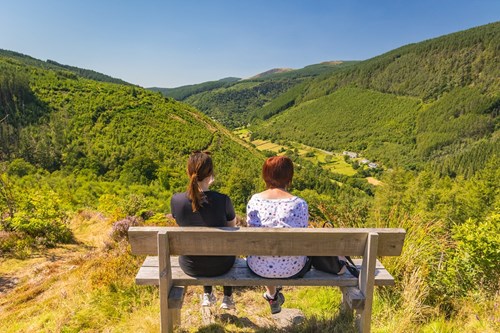
From here you will see stunning views of Foel Crochan and Godre Fynydd.
There is a bench at the viewpoint for a well-deserved break and a chance to take in the breathtaking views.
Then continue along the top of the hill before the steep descent to the car park.
Foel Friog is part of Dyfi Forest.
Situated between the towns of Machynlleth and Dolgellau, Dyfi Forest lies in the shadow of Cadair Idris.
The woodlands cling to the steep hillsides of the Tarren and Dyfi mountain ranges cut through by the Dysynni, Dulas and Dyfi rivers heading west to the nearby sea.
The whole area was once filled with thriving slate mines, employing hundreds of people.
The finished slate was moved to the coast via a system of tramways and steam trains for export.
The remaining trains now carry holidaymakers through the countryside.
Try our waymarked trails for a taste of the area's history and culture and experience the cascading rivers and majestic trees.
In addition to Foel Friog, there are walking trails in these other Natural Resources Wales woodlands within Dyfi Forest:
Most of Dyfi Forest is in Eryri (Snowdonia) National Park.
Eryri is the largest National Park in Wales and is home to picturesque towns and villages and the highest mountain in Wales.
It is looked after by the Eryri National Park Authority.
For more information about visiting Eryri go to the Eryri National Park Authority website.
Dyfi Forest forms part of the National Forest for Wales.
The National Forest will:
It will form a connected ecological network running throughout Wales, bringing social, economic and environmental benefits.
Parts of the network will eventually form a trail running the length and breadth of Wales, so anyone can access it wherever they live.
For more information go to the National Forest for Wales website.
We want you to return home safely after your visit here.
You are responsible for your own safety as well as the safety of any children and animals with you during your visit.
For advice and tips to help you plan your visit here go to Visiting our places safely.
Facilities include:
See the top of this webpage for details of any planned closures or other changes to visitor facilities here.
For your safety, always follow instructions from staff and signs including those for trail diversions or closures.
We may divert or close trails whilst we undertake maintenance work or other operations and we may need to close other visitor facilities temporarily.
In extreme weather, we may close facilities at short notice due to the risk of injury to visitors and staff.
You may need permission from us to organise an event or to carry out some activities on our land.
Check if you are allowed to use our land.
Foel Friog is 6½ miles from Machynlleth.
The postcode is SY20 9RR.
Please note that this postcode may not take you to the car park if you use a sat nav or navigation app.
We suggest you follow the directions below or use the Google map on this page which has a pin on the car park’s location.
Take the A487 from Machynlleth towards Dolgellau.
In Corris, turn sharply right following the signs for Aberllefenni.
Continue for about 1½ miles and the car park is on the right, immediately before the Aberllefenni village sign.
View this place on the What3Words website.
The Ordnance Survey (OS) grid reference for the car park is SH 769 093 (Explorer Map OL 23 or 215).
The nearest mainline railway station is in Machynlleth.
For details of public transport go to the Traveline Cymru website.
Sustrans National Cycle Route 8 goes to Foel Friog.
For more information see the Sustrans website.
Parking is free of charge.
There is a height restriction barrier at the car park entrance and vehicles that are taller than 2.1 metres/6 feet 8 inches cannot enter the car park.
Overnight parking is not permitted.
There are no staff at this location.
Contact our customer team for general enquiries during office hours, Monday to Friday.


