
Beddgelert Forest, near Beddgelert
Huge forest in the heart of Eryri (Snowdonia)...

Hafna car park is near the old Hafna lead mine.
Discover the rich mining heritage on the walking trail that winds its way through several mines, each with their own story.
You can find out what life was like for the miners by listening to our audio trail which has been designed for use along the walking trail.
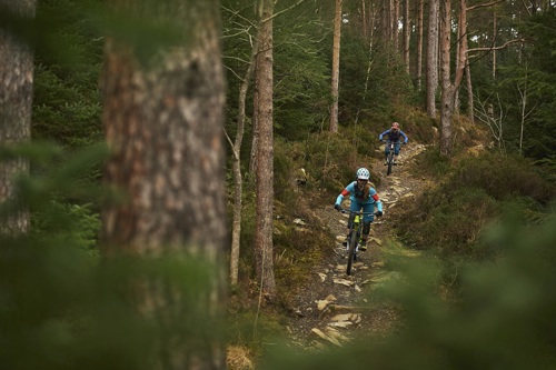
A red-graded mountain bike trail also starts from here.
The walking trail is waymarked from start to finish.
Look out for the information panel at the start of the trail.
Find out about walking trail grades.
Start in the car park that sits below the ruins of Hafna Mine.
The forest has started to encroach into the mine remains yet if you look around the ruins you can imagine the toil that once went on here.
Thread your way across forest-clad hillsides, past a deep cutting, capped mine shafts and the remains of long abandoned mine buildings.
Discover what life was like for the miners by listening to our Gwydir Miners’ audio trail.
The audio trail has been designed to be used along the Hafna Miners’ Trail, a waymarked walking route through the lead mine ruins.
We recommend that you download the audio trail to your smartphone before your visit as mobile network coverage can be limited in rural areas.
You can also download a PDF file of the audio trail’s script from the downloads section at the bottom of this page.
All our mountain bike trails are waymarked from start to finish and have been graded for difficulty.
At the start of the trail there is an information panel – please read this before setting off.
Gwydir Mawr is one of the original mountain bike trails and is a true classic.
Big climbs, big descents, brilliant singletrack and truly awesome scenery make this a trail to remember.
Now including a brand new two kilometre section with a mix of traditional hand dug trail and modern flow trail features.
You can also start Gwydir Mawr from Sawbench car park.
Hafna is in Gwydir Forest Park.
Gwydir Forest Park lies in the heart of the Eryri (Snowdonia) National Park and encircles the village of Betws-y-coed.
Lead and zinc mining once dominated the area and the legacy of old engine-houses, waste tips and reservoirs are characteristic features of the forest landscape today.
Several of the most important mines have been partially restored and made safe for visitors.
Waymarked trails start from Betws-y-coed and several other Natural Resources Wales car parks in Gwydir Forest Park:
Gwydir Forest Park is set in Eryri (Snowdonia) National Park.
Eryri is the largest National Park in Wales and is home to picturesque towns and villages and the highest mountain in Wales.
It is looked after by the Eryri National Park Authority.
For more information about visiting Eryri go to the Eryri National Park Authority website.
Gwydir Forest Park forms part of the National Forest for Wales.
The National Forest will:
It will form a connected ecological network running throughout Wales, bringing social, economic and environmental benefits.
Parts of the network will eventually form a trail running the length and breadth of Wales, so anyone can access it wherever they live.
For more information go to the National Forest for Wales website.
We want you to return home safely after your visit here.
You are responsible for your own safety as well as the safety of any children and animals with you during your visit.
Please note:
For advice and tips to help you plan your visit here go to Visiting our places safely.
See the top of this webpage for details of any planned closures or other changes to visitor facilities here.
For your safety, always follow instructions from staff and signs including those for trail diversions or closures.
We may divert or close trails whilst we undertake maintenance work or other operations and we may need to close other visitor facilities temporarily.
In extreme weather, we may close facilities at short notice due to the risk of injury to visitors and staff.
You may need permission from us to organise an event or to carry out some activities on our land.
Check if you are allowed to use our land.
Hafna is 1½ miles south west of Llanrwst.
The postcode is LL27 0JB.
Please note that this postcode may not take you to the car park if you use a sat nav or navigation app.
We suggest you follow the directions below or use the Google map on this page which has a pin on the car park’s location.
Take the B5106 from Llanrwst towards Betws-y-coed.
After turning left at the brown and white sign for Gwydir Castle, turn immediately right onto a minor road.
Go past the Sawbench car park, continue for around 1 mile and the Hafna car park is on your right.
View this place on the What3Words website.
The Ordnance Survey (OS) grid reference for the car park is SH 781 600 (Explorer Map OL 17).
The nearest mainline railway station is in Llanrwst.
For details of public transport go to the Traveline Cymru website.
Parking is free of charge.
Overnight parking is not permitted.
There are no staff at this location.
Contact our customer team for general enquiries during office hours, Monday to Friday.


