
Beddgelert Forest, near Beddgelert
Huge forest in the heart of Eryri (Snowdonia)...

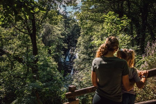
The Ty'n Llwyn car park is the starting point for a walking trail to the famous Swallow Falls waterfall.
The Swallow Falls Trail goes through woodland to a viewpoint over the waterfall - you get a great view from this side of the river so don’t forget your camera.
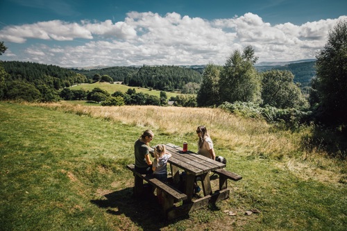
Ty’n Llwyn means “house in the grove” in Welsh and it is a great place to enjoy a picnic with a view at one of the tables around the car park.
The walking trail is waymarked from start to finish.
Look out for the information panel at the start of the trail.
Find out about walking trail grades.
From the car park, the path descends through the woodland and the sound of the river gets louder as you approach Swallow Falls and the viewpoint.
The path then winds its way up through trees and rocky outcrops to another viewpoint with views of Moel Siabod, and in clear weather, the Snowdon Horseshoe.

Facilities for visitors with disabilities at Ty'n Llwyn include:
Ty'n Llwyn is in Gwydir Forest Park.
Gwydir Forest Park lies in the heart of the Eryri (Snowdonia) National Park and encircles the village of Betws-y-coed.
Lead and zinc mining once dominated the area and the legacy of old engine-houses, waste tips and reservoirs are characteristic features of the forest landscape today.
Several of the most important mines have been partially restored and made safe for visitors.
Waymarked trails start from Betws-y-coed and several other Natural Resources Wales car parks in Gwydir Forest Park:
Gwydir Forest Park is set in Eryri (Snowdonia) National Park.
Eryri is the largest National Park in Wales and is home to picturesque towns and villages and the highest mountain in Wales.
It is looked after by the Eryri National Park Authority.
For more information about visiting Eryri go to the Eryri National Park Authority website.
Gwydir Forest Park forms part of the National Forest for Wales.
The National Forest will:
It will form a connected ecological network running throughout Wales, bringing social, economic and environmental benefits.
Parts of the network will eventually form a trail running the length and breadth of Wales, so anyone can access it wherever they live.
For more information go to the National Forest for Wales website.
We want you to return home safely after your visit here.
You are responsible for your own safety as well as the safety of any children and animals with you during your visit.
For advice and tips to help you plan your visit here go to Visiting our places safely.
See the top of this webpage for details of any planned closures or other changes to visitor facilities here.
For your safety, always follow instructions from staff and signs including those for trail diversions or closures.
We may divert or close trails whilst we undertake maintenance work or other operations and we may need to close other visitor facilities temporarily.
In extreme weather, we may close facilities at short notice due to the risk of injury to visitors and staff.
You may need permission from us to organise an event or to carry out some activities on our land.
Check if you are allowed to use our land.
Ty’n Llwyn is 3½ miles west of Betws-y-coed.
The postcode is LL24 0DH.
Please note that this postcode may not take you to the car park if you use a sat nav or navigation app.
We suggest you follow the directions below or use the Google map on this page which has a pin on the car park’s location.
Take the A5 from Betws-y-coed towards Capel Curig.
Go past past the Cae'n y Coed car park and turn right onto the narrow minor road immediately before the Ugly House (Tŷ Hyll).
The small car park is 1 mile up this road, on the right.
View this place on the What3Words website.
The Ordnance Survey (OS) grid reference for the car park is SH 765 583 (Explorer Map OL 17).
The nearest mainline railway station is in Betws-y-coed.
For details of public transport go to the Traveline Cymru website.
Parking is free of charge.
Overnight parking is not permitted.
There are no staff at this location.
Contact our customer team for general enquiries during office hours, Monday to Friday.


